John Q Burbank
| Date of Interment or Death | 09/25/1925 |
|---|---|
| Location | Old Fairview |
| Section | D |
| Block-Lot-Grave | 9-2-1 |
Obituary
JOHN Q. BURBANK, SETTLER OF 1870, DIED WEDNESDAY DEATH COMES AT MINNEAPOLIS FOLLOWING MINOR OPERATION MADE FIRST SURVEY IN RED RIVER VALLEY, 1870
Funeral to Be Held at 2 O’clock This Afternoon From House, and 2:30 From Church
John Quincy Burbank, 77 years old, Richland county surveyor and one of the first settlers in the Red River Valley, died in Minneapolis Wednesday evening, following a minor operation upon his face at the University of Minnesota hospital. Mr. Burbank had been in ill health for some time. He suffered from asthma and had been lame the last few years as the result of a fall.
John Quincy Burbank came west in 1870 and was a member of the first surveying party to run a line through this part of North Dakota. He was sheriff of Richland county in 1874, (its first one) and was the first treasurer of the county. He was elected Judge of Probate in 1875. Later he was in charge of surveying work in southern Richland county. He was assistant clerk of the lower house of the state legislature in 1874 and was representative in 1877-78. For the last thirty-three years, with the exception of two terms, he has been surveyor of Richland county and held that office at the time of his death.
Mr. Burbank grew the first potatoes planted at Fort Abercrombie, carrying the seed from Yankton, his surveying headquarters. He was called to Chicago by Jay Cooke and other builders of the Northern Pacific railroad for a conference on the agricultural possibilities of this state, and is considered largely responsible for the building of that road through this section. Mr. Burbank at that time had the best knowledge of the southern part of the Dakota Territory of any man, having traveled over most of it horseback and afoot.
Surviving him are Mrs. Burbank, his wife, and a brother, Brainerd Burbank of Bethel, Maine. The body is to arrive at Wahpeton on the Milwaukee train this morning and the funeral will be held this (Friday) afternoon, at 2 o’clock from the house and at 2:30 o’clock from the Congregational church, the Rev. E. A. Allin officiating.
BURBANK RECALLS EARLY HISTORY DAKOTA IN 1870 WAS WITH FIRST GOVERNMENT SURVEYING PARTY TO TRAVERSE THIS SECTION RAN LINE MARKING WEST, SOUTH LINES OF RICHLAND Went Through From Yankton to Pembina That Summer and Reported No Settlers Hereabouts
John Q. Burbank of Wahpeton and M. P. Propper of Liderwood were in Fargo Friday as guest of the Red River Valley Old Settlers Association, where Mr. Burbank was asked to talk about the early days in the Valley. He was a member of the first surveying party to run a line through this section, working out of Yankton north in 1870. Mr. Burbank talked of the early days, the absence of settlers hereabouts, and gave a few bits of the early history of Richland county. The 7th Standard Parallel to which he refers is the line which now forms the southern boundary of Richland county and North Dakota. The 7th Guide meridian is the western line of Richland county, which he refers to has having extended north to the Canadian border. Thus it will be seen that the territory of Richland county was included in the first survey made in the Valley. Mr. Burbank said in part:
In the Spring of 1879, I found myself at Yankton. I was twenty two years of age.
The Congress, the winter before this, had appropriated $10,000 for surveys in the Red River Valley on the Dakota Territory side of the Red. This work was given to three men, namely, Rollin J. Reeves, Miles T. Wooley and George N. Propper. (George Propper was a brother of M. P. Propper, who is a resident, at the present time of Lidgerwood, N. Dak.) These three men left Yankton together in July 1870. I was a member of Reeves’ crew, serving as an instrument man.
In addition to our surveying instruments, we had our supplies and camp outfit for a five months campaign. Our route took us via Sioux Falls 65 miles. At Sioux Falls there were two small log houses. North from this point, about one hundred fifty miles was Browns Valley. Here Col. Joseph R. Brown was located. He lived in a one and a half story log house. Col. Brown was a licensed Indian trader. He had a squaw wife. We traveled from Browns Valley to a point on what is now the south boundary of North Dakota on the Bois de
Sioux river. Here our survey began by the extension of the 7th Standard Parallel from the Minnesota Surveys as a base for our work. The carrying of this line across the Bois de Sioux river marked the beginning of the first survey in North Dakota. These three men ran all the Standard and Township lines from the Bois de Sioux and Red River west to the Range line between Ranges 52 and 53 on the 7th Guide Meridian. This 7th Guide we carried north to the British boundary in addition to all the township lines, lying east of the line to the Bois de Sioux and Red Rivers.
There were no settlers in this block of townships. We could not have missed seeing them since we intersected the river every six miles and often on our north and south lines, several times in each township. We had instructions to note the location of all settlers. Fort Abercrombie was occupied by U. S. troops. There were troops at Fort Ransom, about 65 miles northwest of Abercrombie. Fort Wadsworth was about 100 miles S. W. from Fort Abercrombie. Troops were located at that point also.
In 1871 I was appointed by Gen. W. H. H. Beadle, (surveyor General of Dakota Territory) as one of the deputy surveyors, with contract to subdivide ten of these townships. The date of my contract was June 30th, 1871. Eight of these townships were in what is now Cass County one in Richland and one in Traill. Richland and Cass Counties were included in one legislative district. The first county warrant drawn in Richland County was made payable to myself. Warrant No. 1, dated Nov. 26th 1873. I am the present County Surveyor of Richland County and have been for the past thirty years, with the exception of two terms. One of these I declined to serve by a 65 majority. If this record does not make me eligible to be included in the list of “old settlers” of the Red River Valley, I don’t know what will.
Headstone photograph(s)

Location
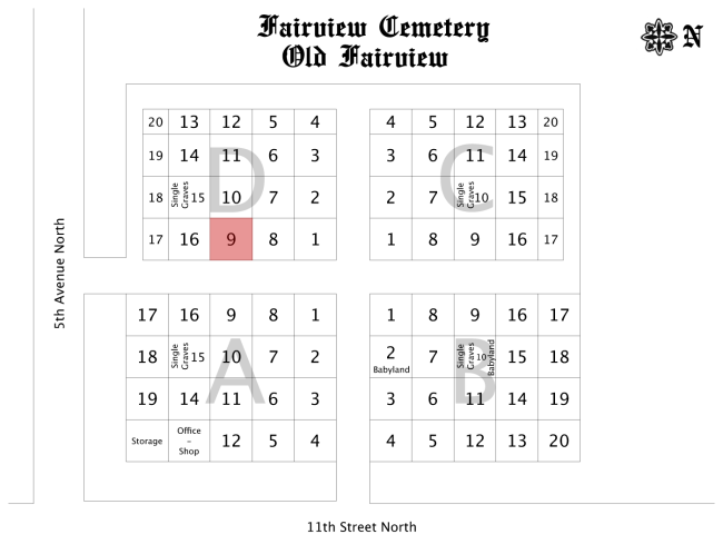
Old Fairview is located on the southern half of the cemetery grounds.